Tag

Google Maps

Browsing

By Chris Smith

While Google owns two popular navigation apps for iPhone and Android, the Waze and Google Maps experiences aren’t identical. Waze offers a simpler navigation user interface that focuses on community-driven information, with incident reports used to improve navigation in real time. Google Maps is more complex, featuring more detailed maps, as well as several features that allow users to discover nearby places of interest, and Gemini AI integration. Over time, Google has brought Waze’s incident reports to Google Maps, without turning Waze into a Google Maps replica. But Google has been working to bring one useful navigation feature available in Google Maps to Waze: support for traffic lights, a feature that some Waze users have started noticing in the app.

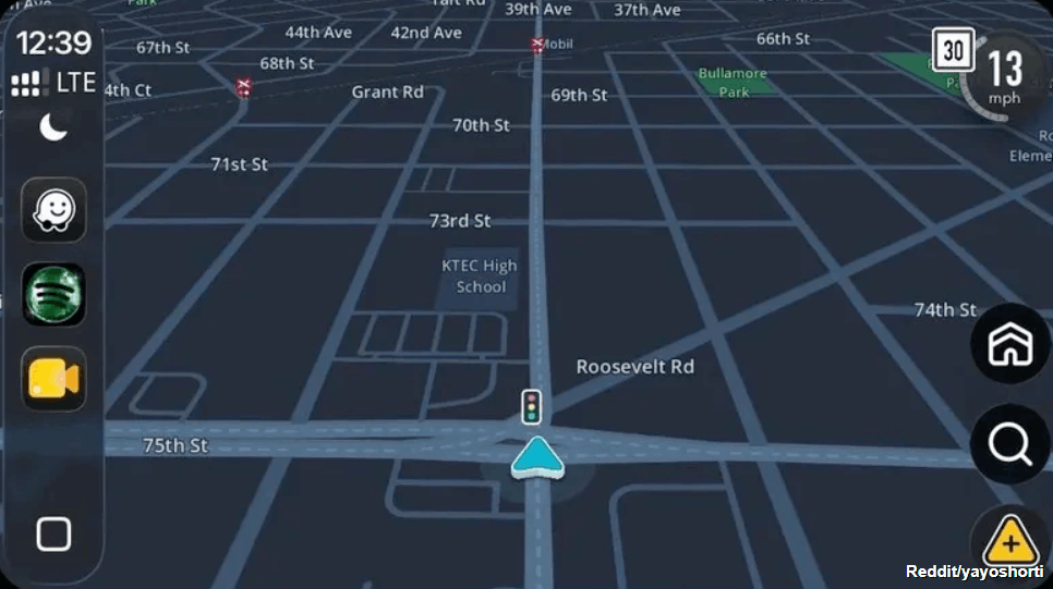
Redditor yayoshorti posted the following screenshot on the social platform in early June 2026, showing the presence of traffic lights on the map. The user asked the community when Waze added the feature, with some other users responding that the feature had been available for them in the app for weeks. But the rollout isn’t complete — not all Waze users see traffic lights during navigation, including users who are Waze editors, according to the responses on the thread. On the other hand, some Waze users confirmed that support for traffic lights has been in testing for a while in various markets, part of Waze’s beta testing.

Separately, 9to5Google noted that the feature had been in testing since December 2025, but more Waze users are starting to see it in the app. It’s unclear when Waze will release the feature more widely.

Why do we need traffic lights in Waze and Google Maps?
Reddit/yayoshorti

Google Maps wasn’t even the first popular mobile navigation app to get traffic lights. Apple Maps rolled out the feature in early 2020, part of the iOS 13 update for the iPhone. Google started testing traffic lights for Google Maps in July 2020, when some Android users spotted traffic lights and stop signs in the app. However, it took over a year for Google to actually roll out the feature, with Google releasing a richer map design in April 2022 that included stop signs and traffic lights.

The purpose of having traffic lights in navigation maps isn’t about speeding up the navigation experience. You can’t set a course from point A to point B and direct the app to avoid all traffic lights like you can with other route options, including tolls and highways. It may be impossible to plan such routes, as traffic lights are frequent, especially in large cities. But there’s a navigation-related reason for traffic lights appearing in Apple Maps, Google Maps, and Waze. These road elements can improve navigation by offering drivers more contextual information about their route.

Traffic lights can be used as landmarks during navigation. For example, Apple insisted on more natural navigation experiences in Apple Maps. Instead of Siri directing users to turn left in 500 meters, it might tell them to turn left at the next traffic light. Google explained in 2022 that a more detailed road design in Google Maps can make the driving experience on unfamiliar roads less stressful. Traffic lights, stop signs, and the actual shape of the road can inform drivers about what’s ahead and make the driving experience safer, as drivers may make fewer last-minute lane changes to ensure they don’t miss the correct turn.

Why hasn’t Google added traffic lights to Waze already?
Kenneth Cheung/Getty Images

Google was quick to follow Apple’s lead with traffic lights in Google Maps. The early 2022 redesign offered users more detailed maps meant to improve the navigation experience by featuring a more accurate road representation than before. Traffic lights were part of the rich Google Maps experience, alongside key road details, like the shape and width of the road, with Google including the medians and islands you might see while driving. Also, the Google Maps update included “enhanced details like building outlines and areas of interest.” The update was bigger than showing traffic lights and stop signs. But Google Maps isn’t used only for driving. You can navigate a known or foreign city with Google Maps while walking or using public transit. Google Maps also allows the quick discovery of restaurants, shops, and other businesses along the way.

Since Google combined its Google Maps and Waze teams in late 2022, Google Maps and Waze users may have expected a more cohesive experience between the two applications. However, Waze remains a standalone app that offers a more barebones navigation experience with the focus on efficiency. The crowdsourced incident reports are Waze’s signature feature, one that users loved as it allowed them to save time by routing around traffic more quickly than Google Maps and other apps. The visual appearance of the maps in Waze doesn’t seem to be as important as Google Maps. That’s all speculation based on what Google did in recent years with Google Maps and Waze, however.

Also important is the involvement of the Waze community in rolling out support for traffic lights. A Waze post from February 2026 indicates that Waze editors who are level 3 or higher can add traffic lights to maps.

Feature image credit: lilaclion/Shutterstock

By Chris Smith

Sourced from BGR

By

Google Maps on iPhone and Android has added several new features to make your commute smoother.

To celebrate the 15th anniversary of Google Maps, Google is rolling out a big update to its planning and navigation app for iPhone and Android that will give you more detailed information about what you’re facing if you use public transportation to get around.

Since its launch in 2005, Google has expanded Maps from a navigation tool to a fuller-featured travel and entertainment service that can help you do everything from make dinner reservations and manage trip itineraries to find EV charging stations along your route.

The update expands Maps’ usefulness for public transit riders, displaying how crowded or hot a route may be, as well as if security is normally present during the trip.
More on Google Maps

Google redesigns Maps app, adds details on public transit safety, accessibility
6 hidden Google Maps tricks you want to know
4 weird ways I use Google Maps every day (that have nothing to do with driving)

Here’s how to use Google Maps’ newest transit features.
Using the new Google Maps transit tools

The new Google Maps update moves forward several useful tools you had to previously hunt for and expands the information it provides you about your public transit trips. Here are Google Maps’ five new tabs and how to use them.

Explore. In the Explore tab, you can discover what’s happening around you and find places to eat and things to do.
Google Maps Update

Google Maps shows displays rider-supplied transit information.
Google

Commute. A holdover from the previous version of Maps, on this tab you can get step-by-step instructions here for your trip — if traveling by car, by transit system, on foot or by bike.

Right now, you can already see how crowded — or empty — your bus, subway, or train will be when you pick your transit line. With the update, you can also see rider-supplied information on which accessibility features are available, what the temperature is like, if there is a women’s-only section or carriage, and if security is present.

Saved. Your saved places used to be buried in the navigation menu in the upper left-hand corner. You can now find those places you’ve saved under the Saved tab at the bottom of the Maps app.

Contribute. The Contribute tab, previously named Your contributions, lets you share reviews and photos of interesting places you’ve visited, add a missing place on the map and suggest edits to the map. If you join Google’s Local Guides program, you can earn points for your contributions and earn rewards such as a free six-month subscription to Google One.

Updates. This new tab is a bit like the older For you tab, letting you see what’s happening around you, with guidance from locals and from publications such as Surface and The Infatuation.

If you don’t have the new version yet, hold on because it is coming: Google tends to push out app updates slowly — over days and weeks. For more about Google’s navigation app, see six hidden tricks for Maps and four ways to use Maps without driving.

By

Sourced from C/NET

By Jason Aten

With iOS 13 comes a major update that might just convince you to stop using Google for this important task.

It’s one of the most fundamental things people do on their smartphone every day, and for years, even if you were using an iPhone, there’s a pretty good chance you were using Google to do it. Specifically, Google Maps.

Headed to an appointment, pull up directions in Google Maps. Going on vacation? Google Maps. Looking for a store or restaurant in town? Google Maps. Ordering lunch to be delivered? Google Maps does that, too.

Sure, you can do most of those things using Apple’s native Maps app, but for much of the first five years of its existence, you were just as likely to end up being told to turn down a road that doesn’t exist. That’s a big problem for an app whose job is to provide accurate directions from point A to point B.

That’s because Apple Maps was really bad. Apple even admitted it. Not only that, but in addition to apologizing for how bad the app was, it actually recommended using Google Maps instead. So most people did.

So, Apple started rebuilding its app the hard way. Instead of purchasing maps from third-party vendors, which caused problems with updates and data, the company started its own mapping initiative. Like Google, it sent out vehicles to take photographs for street level views of buildings and locations.

And, over time, Apple Maps got better. It still had a long way to go before people were willing to trust it for directions to an important meeting, but it was clear Apple was serious about making Apple Maps the navigation choice for iOS users.

Now that iOS 13 has been released, Apple has started rolling out major improvements it previewed at the company’s Worldwide Developer Conference this summer. That includes a range of features, but the one that users will notice right away is simple–it just looks better. Like, a lot better. Apple has updated the overall interface and added substantially more detail to a wide area of the country, including most of the Northeast and California.

That detail includes far more topographical detail along with new, higher-res images in the “Look Around” feature (think: Google Street View). It also includes greater detail of green space, as well as water features. New integrations with third-party apps like Uber make it easier to book a rideshare, though it still lacks the food ordering capability of Google Maps.

It also lags behind Google in one other important way–it only offers transit directions in 10 major cities, compared to the virtually universal offerings from Google. I’ve used it in New York City, and it works great. In fact, I found it more helpful than Google’s version. I especially liked the real-time arrival information. But in most cities, you’re on your own for now.

Of course, Apple says it’s just starting, with the rest of the U.S. to be updated by the end of the year. That fast pace shows just how seriously Apple wants you to stop using Google Maps.

Apple’s motivation is simple–besides the fact that Maps was a major embarrassment, the company is committed to reducing the ways Google monetizes iOS users. With over one billion devices running iOS, that’s no small amount of money for either company.
And with these updates, Apple Maps is now at least a worthy contender, one the company hopes will finally convince you to tell Google Maps to “get lost.”

Feature Image Credit: Getty Images

By Jason Aten

Sourced from Inc.

By Alexis Reliford

In search of a plumber or tow company? Don’t call just any business listing you come across on Google Maps.
A Wall Street Journal report found that about 11 million businesses shown on Google Maps are fake, with new listings and phones numbers cropping up each month. So that florist who never called you back? Maybe not a thing! Many of the listings are created for and by other companies that want to boost their own business info ahead of competitors in the search results, while others are simply scams.
In a blog post, Google responded to the WSJ report and shared that in the last year they had removed more than 3 million fake listings, with more than 90% of those removed before a user even saw them. The company noted its internal systems flagged “more than 85% of these removals” and more than 250,000 fake profiles were reported by users. So if you run across something that seems fraudulent, don’t hesitate to turn it in.
Google typically verifies if a business is legit by calling, mailing a postcard, or emailing a numerical code that is then entered on the website. It’s a pretty easy process for savvy scammers who likely use fake addresses and businesses for their listings anyway. Knowing this, the company says that they are constantly developing new ways to weed out fake listings, but can’t elaborate on what they are due to the sensitive nature.
“Every month Maps is used by more than a billion people around the world, and every day we and our users work as a community to improve the map for each other,” Google Maps’ product director, Ethan Russell, wrote in the blog post. “We know that a small minority will continue trying to scam others, so there will always be work to do and we’re committed to keep doing better.”
In the meantime, the WSJ shared simple ways users could protect themselves from scams, including being wary of business names with keywords like “dependable” or “emergency,” screening phone numbers, and taking reviews with a grain of salt.

Feature Image Credit: Valentin Wolf/imagebroker/Shutterstock.

By Alexis Reliford

Sourced from Refinery29