Tag

Waze

Browsing

By Chris Smith

While Google owns two popular navigation apps for iPhone and Android, the Waze and Google Maps experiences aren’t identical. Waze offers a simpler navigation user interface that focuses on community-driven information, with incident reports used to improve navigation in real time. Google Maps is more complex, featuring more detailed maps, as well as several features that allow users to discover nearby places of interest, and Gemini AI integration. Over time, Google has brought Waze’s incident reports to Google Maps, without turning Waze into a Google Maps replica. But Google has been working to bring one useful navigation feature available in Google Maps to Waze: support for traffic lights, a feature that some Waze users have started noticing in the app.

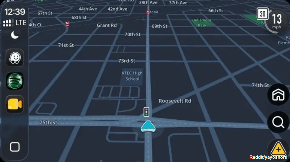
Redditor yayoshorti posted the following screenshot on the social platform in early June 2026, showing the presence of traffic lights on the map. The user asked the community when Waze added the feature, with some other users responding that the feature had been available for them in the app for weeks. But the rollout isn’t complete — not all Waze users see traffic lights during navigation, including users who are Waze editors, according to the responses on the thread. On the other hand, some Waze users confirmed that support for traffic lights has been in testing for a while in various markets, part of Waze’s beta testing.

Separately, 9to5Google noted that the feature had been in testing since December 2025, but more Waze users are starting to see it in the app. It’s unclear when Waze will release the feature more widely.

Why do we need traffic lights in Waze and Google Maps?
Reddit/yayoshorti

Google Maps wasn’t even the first popular mobile navigation app to get traffic lights. Apple Maps rolled out the feature in early 2020, part of the iOS 13 update for the iPhone. Google started testing traffic lights for Google Maps in July 2020, when some Android users spotted traffic lights and stop signs in the app. However, it took over a year for Google to actually roll out the feature, with Google releasing a richer map design in April 2022 that included stop signs and traffic lights.

The purpose of having traffic lights in navigation maps isn’t about speeding up the navigation experience. You can’t set a course from point A to point B and direct the app to avoid all traffic lights like you can with other route options, including tolls and highways. It may be impossible to plan such routes, as traffic lights are frequent, especially in large cities. But there’s a navigation-related reason for traffic lights appearing in Apple Maps, Google Maps, and Waze. These road elements can improve navigation by offering drivers more contextual information about their route.

Traffic lights can be used as landmarks during navigation. For example, Apple insisted on more natural navigation experiences in Apple Maps. Instead of Siri directing users to turn left in 500 meters, it might tell them to turn left at the next traffic light. Google explained in 2022 that a more detailed road design in Google Maps can make the driving experience on unfamiliar roads less stressful. Traffic lights, stop signs, and the actual shape of the road can inform drivers about what’s ahead and make the driving experience safer, as drivers may make fewer last-minute lane changes to ensure they don’t miss the correct turn.

Why hasn’t Google added traffic lights to Waze already?
Kenneth Cheung/Getty Images

Google was quick to follow Apple’s lead with traffic lights in Google Maps. The early 2022 redesign offered users more detailed maps meant to improve the navigation experience by featuring a more accurate road representation than before. Traffic lights were part of the rich Google Maps experience, alongside key road details, like the shape and width of the road, with Google including the medians and islands you might see while driving. Also, the Google Maps update included “enhanced details like building outlines and areas of interest.” The update was bigger than showing traffic lights and stop signs. But Google Maps isn’t used only for driving. You can navigate a known or foreign city with Google Maps while walking or using public transit. Google Maps also allows the quick discovery of restaurants, shops, and other businesses along the way.

Since Google combined its Google Maps and Waze teams in late 2022, Google Maps and Waze users may have expected a more cohesive experience between the two applications. However, Waze remains a standalone app that offers a more barebones navigation experience with the focus on efficiency. The crowdsourced incident reports are Waze’s signature feature, one that users loved as it allowed them to save time by routing around traffic more quickly than Google Maps and other apps. The visual appearance of the maps in Waze doesn’t seem to be as important as Google Maps. That’s all speculation based on what Google did in recent years with Google Maps and Waze, however.

Also important is the involvement of the Waze community in rolling out support for traffic lights. A Waze post from February 2026 indicates that Waze editors who are level 3 or higher can add traffic lights to maps.

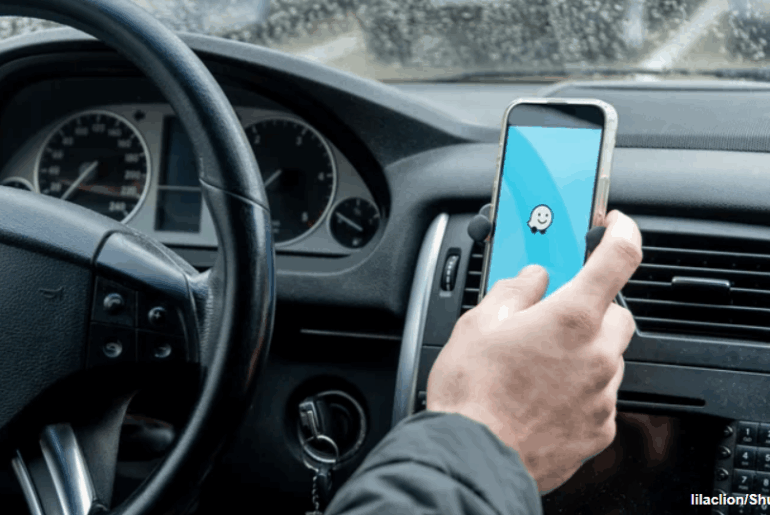
Feature image credit: lilaclion/Shutterstock

By Chris Smith

Sourced from BGR

By Matthew Zucca

Waze hit with a round of layoffs amid Google’s consolidation efforts

The technology industry is seeing a significant trend of job cuts recently. Both large and small tech companies are resorting to layoffs to adapt to evolving market conditions and enhance efficiency. Likewise, in a significant restructuring move, Google has announced that it will lay off a number of employees from its Waze mapping service. The action is a part of a shift to align Waze’s ad monetization with the current Google Maps ad model by integrating it with Google’s Global Business Organization (GBO).

The technology industry is seeing a significant trend of job cuts recently. Both large and small tech companies are resorting to layoffs to adapt to evolving market conditions and enhance efficiency. Likewise, in a significant restructuring move, Google has announced that it will lay off a number of employees from its Waze mapping service. The action is a part of a shift to align Waze’s ad monetization with the current Google Maps ad model by integrating it with Google’s Global Business Organization (GBO).

As CNBC reports, this recent round of layoffs at Waze is the company’s second in this year (via 9to5Google). Positions associated with Waze’s advertising operations, including in sales, marketing, operations, and analytics, are the major targets of the decision to remove employment. However, the specific amount of job losses is still unknown.

Chris Phillips, the head of Google’s mapping division Geo, described the change in Waze’s strategy in an internal email that CNBC was able to access. The shift involves gradually phasing out the present Waze Ads product and replacing it with a system powered by Google Ads in order to “build a more scalable and optimized Waze Ads product.”

Despite the workforce cut, Google reaffirmed its commitment to the Waze platform and app, specifically calling out its “thriving community of volunteers and users” in a statement about the layoffs.

Nonetheless, the ongoing integration of Waze into Google’s Geo division that began in late 2022 has brought substantial changes, including Neha Parikh’s resignation as CEO. After a year of sluggish revenue growth for Alphabet, stakeholders view the restructuring as a proactive step towards increased efficiency. Users, however, will see parallels with Google’s integration of Nest into its main hardware division, a move that has been criticized as having taken away Nest’s unique identity.

Waze is well recognized for its crowdsourcing technique, which enables the program to determine the shortest driving routes using real-time traffic data from over 140 million active users. Since Google acquired it in 2013, it has continued to operate as a distinct legal entity under Google’s management, but that appears to be changing after these recent developments.

Google intends to provide further information about this transition on July 11 during the upcoming Waze Town Hall meeting.

By Matthew Zucca

Sourced from Android Police


By

You may have used the Waze app to avoid traffic, but what if that data could be used to fight traffic data on a larger scale? That’s what the Waze for Cities Data program aims to do. Waze is making anonymized user data available to cities for free on Google Cloud and adding the tools to help urban planners analyze it.

Waze for Cities Data launched in 2014 as the Connected Citizens Program. It started with 10 city partners and has since grown to 1,000 partners globally, according to Waze, encompassing both cities and other entities that can make use of the app’s crowdsourced traffic data. Partners will now have access to Waze data collected since April 2019 via Google Cloud, as well as analysis tools BigQuery and Data Studio, which were designed to make sense even to lay audiences, according to Waze.

What can users do with this data? Genesis Pulse, an emergency services software provider, started using Waze data to give first responders real-time crash alerts from Waze users. In 40% of cases, crashes are reported by Waze users 4.5 minutes before they are called in via 911 or an equivalent method, according to Waze. According to the Federal Communications Commission, a one minute decrease in average ambulance response time saves more than 10,000 lives in the United States annually, Waze noted.

Public agencies that apply for the program can analyze up to 1TB of data, and store up to 10GB of data, for free each month. The basic data analysis tools are free as well, but more advanced tools will require a paid account. Cities will also be able to store and analyze their own data, while maintaining complete control of it, according to Waze.

Waze’s data-sharing scheme is already proving popular. The top three contributors are the cities of Seattle, Los Angeles, and San Jose, according to Waze. The government of Miami-Dade County and the state transportation agencies of Massachusetts and Virginia are also major contributors, as are both New York City and the Port Authority of New York and New Jersey, which operates large chunks of the Big Apple’s transportation infrastructure. So the next time you open up the Waze app, know that you may be helping to fight urban traffic.

Feature Image Credit: Andy Boxall/Digital Trends

By

Sourced from Digital Trends